What you need to know about Idalia's journey through the Caribbean 1:32
(CNN) -- Idalia strengthened to a hurricane with maximum sustained winds of 120 km/h with stronger gusts, according to the 5 a.m. update from the National Hurricane Center.
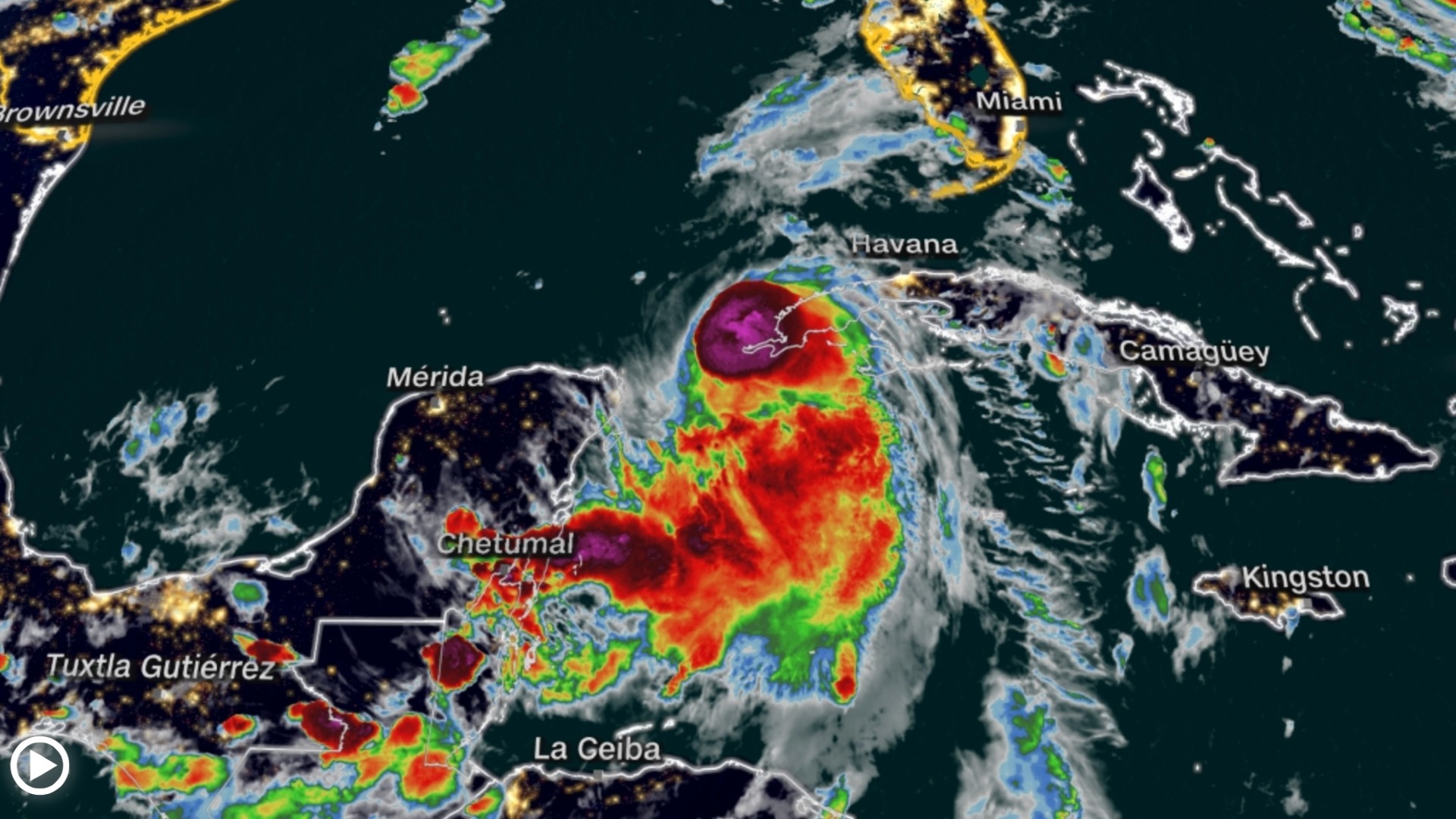
Hurricane Idalia is located 136 km north of the western tip of Cuba, is moving north at 22 km/h and is expected to intensify considerably before making landfall in Florida on Wednesday as a powerful Category 3 hurricane.
Idalia could deal a devastating blow to parts of Florida's Gulf Coast, with storm surges and damaging winds that would be life-threatening. The storm is expected to make landfall well north of Tampa in Florida's Big Bend, but a small change in trajectory could put the vulnerable population center at greater risk.
In addition, Idalia could produce some tornadoes along Florida's west-central coast today and northward into Florida's Big Bend at night. Heavy rains could produce flash flooding across portions of Florida's west coast, northwest Florida, and southern Georgia from Tuesday through Wednesday, extending to portions of the eastern Carolinas Wednesday through Thursday.
- Tropical Storm Idalia's Track Live: Where It's in Real-Time and Where It's Headed
"This is going to be a major hurricane," Gov. Ron DeSantis said at a news conference Monday.
advertising
On its current trajectory, central Idalia is forecast to soon pass near or over western Cuba, traverse the eastern Gulf of Mexico on Tuesday, before crashing into the Florida Gulf Coast on Wednesday, though its impacts could be felt as soon as the Florida Keys on Tuesday.
It's not just Florida that will feel the impacts. After the storm makes landfall, damaging winds and heavy rain will spread inland to Florida, parts of Georgia and even the Carolinas.
The storm is expected to dump 101 to 203 millimeters of rain Tuesday through Thursday in parts of Florida's west coast, the Florida Panhandle, southeast Georgia and the eastern Carolinas, where streets could flood.
As the storm moves toward Florida, preparations can be seen across the state. Here's the latest:
- Airport closures: Tampa International Airport will suspend all business operations starting Tuesday and remain closed until it can assess damage later in the week, airport officials announced. The terminal building at St. Pete-Clearwater International Airport will close Tuesday afternoon.
- Evacuations in at least 10 counties: Hillsborough, Franklin, Taylor, Levy, Citrus, Manatee, Pasco, Hernando, Pinellas and Sarasota counties have asked residents to evacuate certain at-risk areas.
- Schools close: 32 county school districts have issued closures, as have several colleges and universities, including Florida State University, the University of Florida and Florida A&M University.
- Declared emergencies: DeSantis expanded an emergency declaration to 46 of Florida's 67 counties Monday morning. Several local jurisdictions have also declared emergencies.
- The Florida National Guard was activated: More than 5,000 National Guard members were activated to help respond to the storm.
- U.S. Navy ships begin to depart: Navy ships have begun leaving Florida before Tropical Storm Idalia makes landfall, the Navy said Monday.
- Power outages are expected: DeSantis told residents to prepare to run out of power. "If you find yourself in the path of the storm, you should expect power outages, so be prepared for that," the governor told residents Sunday.
- Suspension of services of the hospital system: Patients will be transferred from at least three hospitals: HCA Florida Pasadena Hospital, HCA Florida Trinity West Hospital and HCA Florida West Tampa Hospital.
"We want everyone to take this storm seriously," Tampa Fire Department Chief Barbara Tripp said during a news conference.
The Fire Marshal also asked citizens to remove debris from properties before the storm hits and keep an eye out for neighbors who may need help.
- Tropical Storm Idalia in Florida live: track, breaking news, news and more
"Once the wind reaches certain miles per hour, Tampa Fire Rescue will not be able to respond," Tripp warned.
Since the storm is forecast to strengthen rapidly as it moves through the Gulf of Mexico, it will touch some of the warmest waters on the planet before making landfall in Florida.
If it does, it would join a growing list of devastating storms like the monster Hurricane Ian, which ripped through the Florida coast and left more than 100 dead, rapidly intensifying before making landfall in recent years.
Idalia represented a "notable risk" of this phenomenon, the National Hurricane Center warned on Monday, as it passed through the Gulf of Mexico.
Water temperatures around South Florida climbed to 38 degrees Celsius in some areas this summer, and temperatures in the Gulf overall have been record highs, with more than enough heat to withstand rapid strengthening.
Storm surge 'life-threatening'
A team helps residents with sandbags Monday in Tampa, Florida. (Credit: Chris O'Meara/AP)
Potentially deadly storm surges of up to 3.6 meters are possible in Florida's Big Bend, a danger that will only worsen with waves fueled by hurricane-force winds of more than 160 km/h.
Storm surge, which occurs when a storm blows the ocean toward the coast, is one of the deadliest aspects of a hurricane and the reason behind most storm evacuations.
Cedar Key could be cut off by the strong storm surge, National Hurricane Center Deputy Director Jamie Rhome said.
"I'm especially concerned about them," Rhome said during a Facebook Live briefing. "If you are watching from Cedar Key, it is imperative that you take this very seriously and, if ordered to evacuate, pay attention to those evacuations immediately. In conditions like that, the whole island could be completely isolated."
- Which countries and states are threatened by Tropical Storm Idalia and when would it arrive?
Rhome emphasized that evacuation orders that have been issued along the coast are in place due to the projected storm surge.
Storm surges account for nearly half of all hurricane-related deaths, according to the National Oceanic and Atmospheric Administration.
It's not just coastal areas that could be flooded.
Inland areas, to which people could evacuate, could suffer dangerous flooding and heavy rains from Idalia.
Andrew Kruczkiewicz, a senior researcher at Columbia University's Climate School, warns that hazards related to heavy rainfall can also occur up to 100 miles away from where the center of the storm is located.
"This is something we're seeing more and more, and it's a connection to climate change because we're seeing wetter tropical cyclones and hurricanes," he told CNN. "That's why we need to pay more attention to the risks associated with heavy rainfall, especially in areas far from the coast."
-- CNN meteorologists Robert Shackelford and Taylor Ward, as well as CNN's Mary Gilbert, Melissa Alonso, Devon Sayers and Jennifer Henderson contributed to this report.
FloridaHurricaneIdaliaTropical Storm