In the coming week, there will be two waves of northeast monsoons of equal intensity, which will affect the low temperature in the north to drop to about 13 degrees, and locally drop to 11 degrees.
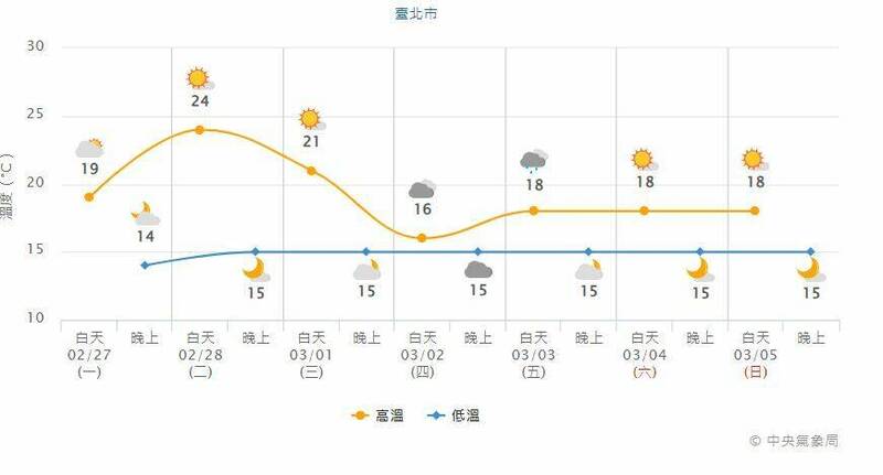
The picture shows the temperature change in Taipei City in the coming week.
(The picture is taken from the Central Meteorological Bureau)
[Reporter Chen Xinyu/Taipei Report] Radiation Cooling Shows Its Power!
The strong continental cold air mass that has been affecting for many days weakened today (27th), but the radiation cooling took off this morning. The lowest temperature was 8.2 degrees in the Houbi District of Tainan City. However, the temperature gradually rose during the day, and the western half was cloudy to sunny. The high temperature has also risen to about 19 degrees, and the high temperature in the central and southern regions has exceeded 20 degrees. In the next week, there will be two waves of northeast monsoons of equal intensity. In addition, there is still no chance of rainfall in the south where the water situation is severe in the near future.
Zhang Chengchuan, a forecaster of the Central Meteorological Bureau, said that the cold air mass in the mainland has weakened today, and the weather in various parts of the country is cold in the early morning, and the temperature gradually rises during the day. Cloudy to sunny.
Please read on...
However, another wave of northeast monsoon is expected to arrive the day after tomorrow. The northeast monsoon will strengthen from Wednesday night, and the northeast monsoon will affect Thursday. The weather in the north and northeast will turn cooler. The average low temperature in the north and Yilan is about 13 degrees. The high temperature is about 15 to 17 degrees; the central and southern regions feel cold about 13 and 14 degrees in the morning and evening, and it is still above 20 degrees during the day. There are local short-term rains in the northern and eastern half, and cloudy to sunny in other areas.
The northeast monsoon weakened slightly on Friday, and the temperature in the northern and Yilan regions rose slightly by 1 to 2 degrees. There were local short-term rains in the northern and Yihuadong regions, and cloudy to sunny in the central and southern regions.
The second wave of northeast monsoon strengthened again on Saturday, and the weather in various places was cooler in the morning and evening; there were local short-term rains in the northern and eastern half, and cloudy to sunny in other areas.
Next Sunday will continue to be affected by the northeast monsoon, and the weather in various places will be cooler in the morning and evening; most of the places will be cloudy to sunny, with only local short-term rain in the east and southeast.
Tomorrow, the western half of the day after tomorrow, and Matsu may have local fog or low clouds that will affect visibility, so pay attention to traffic going back and forth; from today to the day after tomorrow, there may be long waves along the coast of the eastern half (including Green Island and Lanyu) and Hengchun Peninsula.
In addition, on the roads in the north, northeast and east of the central part in the early morning, be careful to prevent icing or slippery road surfaces.