It can be clearly seen from satellite images that a 7.8-magnitude earthquake occurred on the Turkish-Syrian border on the 6th, which caused the level of the fault between Turkey and northern Syria to shift, and caused hundreds of kilometers of surface cracks.
(Picture taken from @Maxar Twitter)
[Instant News/Comprehensive Report] The 7.8-year-old earthquake and strong aftershocks hit the Turkish-Syrian border on the 6th, which caused the fault level between Turkey and northern Syria to shift, and two huge cracks appeared on the ground as if they had been torn apart.
Parts of the land at both ends of the crack even have a lateral displacement of up to 7 meters. The more common crack is located in southern Turkey and stretches for nearly 300 kilometers, which is almost equal to the total length of Taiwan's main island; while the other is shorter, but also about 125 kilometers long.
According to Reuters, Eric Fielding, a geophysicist at NASA's Jet Propulsion Laboratory, said that the earthquakes in Turkey were very strong. fault line up to the surface," noting that the length and magnitude of the ground rupture caused by the strong quake was very similar to the one that devastated San Francisco in 1906.
Please read on...
Tim Wright, director of the United Kingdom's Earthquake Volcano and Tectonic Observation and Modeling Center (COMET), previously told "Space.com" that after the strong earthquake, the surface was torn apart by one of two "longest cracks ever seen". Among them, the longer crack extends 300 kilometers northeast from the Turkish-Syrian border near the Mediterranean Sea; the second crack extends 125 kilometers from west to east in southern Turkey, and part of it is parallel to the first crack.
According to data provided by Caltech expert Chris Milliner, the ground on both sides of the crack is "moving horizontally" in opposite directions.
The magnitude 7.8 main earthquake had a longer displacement of 5 meters, and the subsequent 7.5 strong earthquake had a shorter duration, resulting in ground displacements of up to 7 meters in some areas.
The displacement of the earth can be clearly compared with the satellite images before and after the strong earthquake.
In addition, Reuters compared the rift with maps of various countries and pointed out that this 300-kilometer rift is equivalent to the total length of Taiwan, and almost crosses the territory of most of South Korea or Portugal.
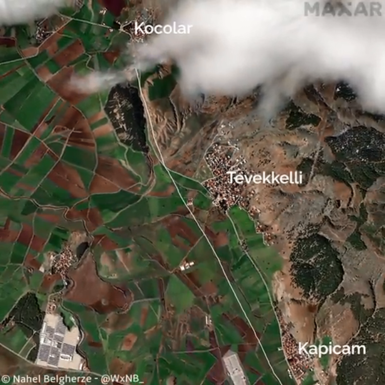
NEW: @Maxar's satellite imagery clearly reveals the multi-km-long surface rupture extending along the Gölbaşı-Türkoğlu segment of the East Anatolian Fault as a result of the 7.8 magnitude earthquake in southern Turkey. pic.twitter.com/915EoWD9
— Nahel Belgherze (@WxNB_) February 13, 2023