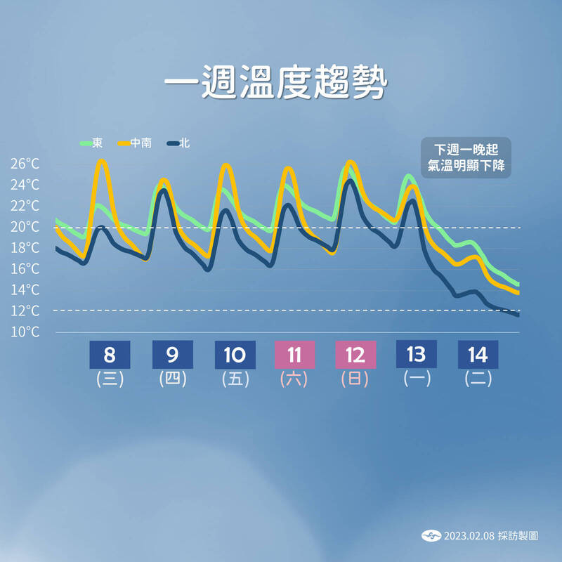
Next Monday, there will be a wave of cold air near a strong continental cold air mass moving southward. Some areas in the central and northern parts will drop by 9 degrees on Tuesday night and Wednesday morning. The picture shows the temperature trend in the coming week.
(Central Weather Bureau)
[Reporter Chen Xinyu/Taipei Report] Winter is not over yet!
The Central Meteorological Administration reminded that there will be a wave of cold air near the strong continental cold air mass going south next Monday. The low temperature bottomed out in the central and northern parts from Tuesday night to early Wednesday morning. Some areas will drop by 9 degrees, and the northern part will be about 12 to 16 degrees all day. The low temperature in the central and southern parts is about 14 to 16 degrees, and the strong cold air continues to affect Thursday.
However, due to the lack of moisture, it is estimated that Yushan, which has not yet had its first snow this year, still has no chance of snow.
Ye Zhijun, a forecaster of the Central Meteorological Bureau, said that today, due to the influence of the northeast monsoon, there will be short-term rain in the eastern half of the area, local short-term rain in the Greater Taipei area and the mountainous areas north of the central part, and cloudy to sunny in other areas; the northeast monsoon will weaken tomorrow and Thursday, and the moisture Even less, the eastern half of the region and the Greater Taipei Mountains will experience some short-term rain, while the western half of the region will be mostly cloudy to sunny.
Please read on...
Ye Zhijun said that waves of the northeast monsoon will affect this week, and the northeast monsoon will strengthen from Friday. For example, on Friday and Saturday, there will be chances of rain in Greater Taipei and the eastern half.
Next Monday night, there will be a nearly strong continental cold air mass moving southward, and the whole Taiwan will gradually turn cold from north to south, and the windward side will receive more rainfall, including local short-term rains in the northern, eastern half, and central mountainous areas.
Next Tuesday (14th) is also the day of Western Valentine's Day. From north to south, it gets colder and colder later, and the impact will gradually weaken until next Thursday.
Ye Zhijun said that from Tuesday night to Wednesday morning, the north of the central part and the northeast will be 12 to 13 degrees, with a local drop of 9 degrees, and the low temperature in other areas will be about 14 to 16 degrees.
Ye Zhijun said that Yushan still seems to be at the bottom of the water vapor, and the chance of snowfall is not high. Since the beginning of winter, Yushan has only seen ice graupel. 3.5 degrees above the climate average (minus 0.5 degrees).
From this evening to tomorrow morning, there will be partial fog or low clouds affecting visibility in the western half of the area, so attention should be paid to traffic going back and forth.
This week's rainfall is concentrated in the greater Taipei area and the eastern half. The picture shows the rainfall trend in the coming week.
(taken from Central Weather Bureau)