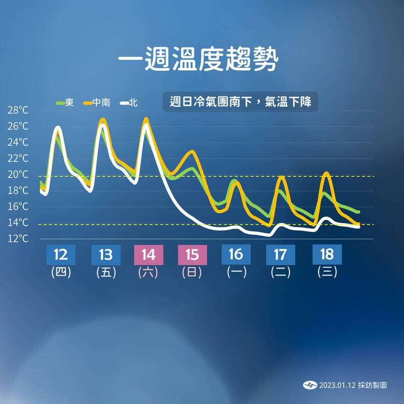
After the front passed late on Saturday night, the continental cold air mass moved south, and next Monday to next Wednesday will be the strongest time for this wave of cold air mass.
This is the weekly temperature trend.
(taken from Central Weather Bureau)
[Reporter Chen Xinyu/Taipei Report] Today to Saturday is good weather for cleaning and drying clothes!
The Central Meteorological Bureau stated that today (12th) the western half was cloudy to sunny, and only the eastern half and the northern mountainous area had sporadic and short-term rain. Saturday was still high temperature and cloudy to sunny during the day, but a front began to approach in the afternoon, affecting the whole Taiwan It turned to rain, and then the front passed, and there will be a continental cold air mass to report next Sunday, and the temperature will drop before the Spring Festival holiday. From next Monday to next Wednesday, some parts of the north of the central part will drop 8 degrees in the morning and evening. It is estimated that before the first day of the Lunar New Year It's weather covered by cold air.
Chen Yixiu, a forecaster from the Central Meteorological Bureau, said that the weather today and tomorrow will be similar. There will be sporadic and short-term rain in the eastern Yihua area and the northern mountainous area. The whole of Taiwan will be mostly cloudy to sunny.
Please read on...
However, the weather will change on Saturday. Although the high temperature in Taiwan is nearly 30 degrees in the morning, there will be a front approaching in the afternoon on Saturday, which will affect the whole Taiwan and turn to local rain. At noon or afternoon on Saturday, the middle layer of water vapor will move in from the mountainous area, and the cloud cover will be over Taiwan. The increase began to rain.
After the front passed late on Saturday night, the continental cold air mass moved southward, and Taiwan will get colder and colder as the night goes on next Sunday.
There will be short-term rain in the northern and northeastern regions next Sunday, and local short-term rain in the south-central region and Taitung.
It will turn dry and cold next Monday, and next Monday to next Wednesday will be the strongest time for this wave of cold air mass. It is estimated that the low temperature in the north of the central part will be about 11 or 12 degrees, and the low temperature will drop by 8 degrees in some open areas; the low temperature in the central and southern parts will be about 14. 15 degrees, local drop 11 degrees.
The northern and eastern half of the region will feel damp and cold, with some short-term rains. The central and southern regions will be cloudy to sunny, and the high temperature will exceed 20 degrees during the day. Pay attention to the large temperature difference between day and night.
It is estimated that the temperature will rise slightly on the 19th and 20th (New Year's Eve), but the weakening of cold air may still be adjusted.
There will be a front approaching on Saturday afternoon, affecting the whole Taiwan with rain, and then the front will pass, and a mainland cold air mass will report next Sunday.
This is the future rainfall trend.
(taken from Central Weather Bureau)