It can be seen from satellite images that a collapse occurred near the confluence of Lele Creek and Magacituo Creek in Zhuoxi Township, resulting in a barrier lake with an area of 4.5 hectares.
(Provided by Hualien Forest Management Office)
[Reporter Hua Mengjing/Hualien Report] The Hualien Forest Management Office of the Forestry Bureau entrusted National Cheng Kung University to regularly monitor the satellite images of the forest area under its jurisdiction, and found that more than 20 hectares of forest land collapsed in the upper mountainous area of Lele River, Zhuoxi Township. A barrier lake appears in the upper valley of the stream.
The Hualien Forest Management Office said that the barrier lake has already overflowed, and it is estimated that there is no immediate danger to the village, but it appeals to the public to try not to go to the stream bed during this period.
The landslide is located in the No. 8 Forest Class of Hsiuguluan Business District, Hualien Forest District, with an area of 27.1 hectares. Earth and rocks are piled up near the confluence of Lele Creek and Magacituo Creek, forming a barrier lake with an area of 4.5 hectares. The dam height is about 20 meters, the backwater length is about 692 meters, and the estimated water storage volume is about 350,000 cubic meters.
Please read on...
After the satellite monitoring image found the barrier lake, the Hualien Forestry Management Office immediately set up a response team, and experts estimated that there was no immediate danger.
The Hualien Forest Management Office of the Forestry Bureau pointed out that the barrier lake is an unstable dam formed by natural earth and rocks, which may collapse at any time. However, the barrier lake has already overflowed, and the water storage capacity has not continued to increase. There should be no immediate danger of embankment collapse. .
According to the Forest Management Office, the National Cheng Kung University assessed that the barrier lake is still 20 kilometers away from the downstream Nan'an and Zhuole tribes. If the dam breaks and the water flows to the downstream tribes, it is estimated that the water level of the river will rise by about 29 to 101 centimeters. On the river terrace, the height difference from the river bed is about 11 meters, and the width of the downstream river section is enlarged, so it will not cause danger
The Forestry Bureau will also hold briefings with the Eastern Joint Service Center of the Executive Yuan, the Ninth River Bureau of the Water Conservancy Administration of the Ministry of Economic Affairs, the Hualien Branch of the Soil and Water Conservation Bureau of the Agricultural Commission of the Executive Yuan, the Zhuoxi Township Office, and the Yuli Township Office, and launch the disaster prevention and response mechanism and For river control, Zhuo Le’s meeting place held a meeting with villagers and officials from Zhuo Qing, Zhuo Le, Nan’an, Qingshui, and Chang Liang of Yuli Township, appealing to the public not to go to the riverbed for activities during this period.
The Hualien Forest Management Office of the Forestry Bureau held a briefing at the Zhuoqing Tribe in Zhuoxi Township, appealing to the public not to go to the creek bed for activities.
(Provided by the Hualien Forest Management Office of the Forestry Bureau)
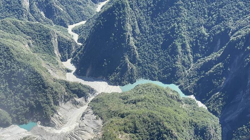
There is a barrier lake near the confluence of Lele River and Magacituo River in Zhuoxi Township, and it is 20 kilometers away from the downstream Nan'an and Zhuole tribes.
(Provided by the Hualien Forest Management Office of the Forestry Bureau)