Today (28th) the whole of Taiwan is warm and hot, but tomorrow night will have the strongest cold air since winter, and the whole of Taiwan will feel the temperature drop from Wednesday.
(Provided by the Central Weather Bureau)
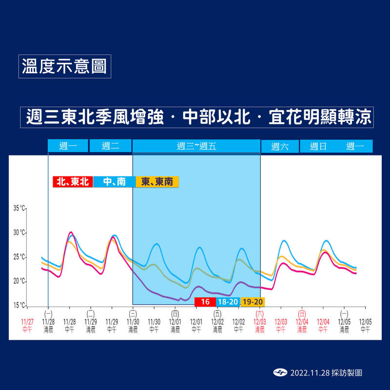
[Reporter Chen Xinyu/Taipei Report] Today (28th) the whole of Taiwan is warm and hot, but tomorrow night there will be the strongest cold air since winter, and the temperature in Taiwan will drop step by step. cold.
Tomorrow evening, due to the strengthening of the northeast monsoon and the influence of the front, the north and east will turn rainy. On Wednesday, it will become more obvious as the night gets colder and colder. The average low temperature in the north is 16 to 17 degrees, and some parts even drop to 13 or 14 degrees. The low temperature in the central part is about 17 degrees. The low temperature in the south is about 18 or 19 degrees, there is rain in the north and central, and the south is still cloudy to sunny.
Huang Enhong, a forecaster from the Central Meteorological Bureau, reminded people in the central and northern regions to remember to bring rain gear before going out tomorrow.
Tomorrow evening, there will be a wave of northeast monsoon heading south and the front will pass. From the evening onwards, the wind will strengthen north of the central part, and the northern and eastern half will begin to rain. 4. It was wet and cold all day on Thursday, and the high temperature was also below 20 degrees, and the feeling was the most obvious from Wednesday night to Thursday morning. The local low temperature dropped by 13 degrees, and the low temperature averaged 16 to 17 degrees.
Please read on...
People in the central region will not feel it tomorrow. It will still be cloudy to sunny during the day, and it will get colder later on Wednesday. The average low temperature on Wednesday and Thursday will be 17 degrees, and some parts will drop to 14 degrees. It will also turn to partial rain at first.
The south will still be cloudy to sunny tomorrow, and it will feel comfortable and cool from Wednesday to Thursday, but it will not rain.
From Wednesday to Friday in the southern region, the temperature will drop by about 3 degrees, the low temperature will be about 18 or 19 degrees, and the high temperature will be about 26 degrees. It will be mostly cloudy and sometimes sunny.
The northeast monsoon has weakened since Friday, but there is still a northeasterly wind blowing. There is a slight temperature rise in various places, but the change is not obvious. There are still some short-term rains in the northern and eastern half of the region, and cloudy to sunny in the central and southern regions.
On Saturday and next Sunday, the water vapor will start to decrease, the northern and eastern half will have more gaps in rainfall, and the flat land will be less rainy.
It is expected that the temperature will rise slightly in the north of the central part, the northeast and the east; there will still be some short-term rain in the northern and eastern half, and cloudy to sunny in other areas.
Another wave of northeast monsoon will be reported next Monday, but the cooling is not as obvious as the wave from Tuesday. It is manifested in rainfall. There are local short-term rains in the northern and eastern half of the country, and cloudy to sunny in the central and southern regions.
Tomorrow, the western half of the region, Kinmen, and Matsu are likely to have low clouds or partial fog that will affect visibility, so please pay attention to traffic going back and forth.
Affected by the strengthening of the northeast monsoon from Wednesday to Friday, the north of Tainan, the eastern half (including Orchid Island and Green Island), the coast of Hengchun Peninsula and Penghu, Kinmen, and Matsu may have long waves, so please pay attention to seaside activities.