Tuesday nights will change!
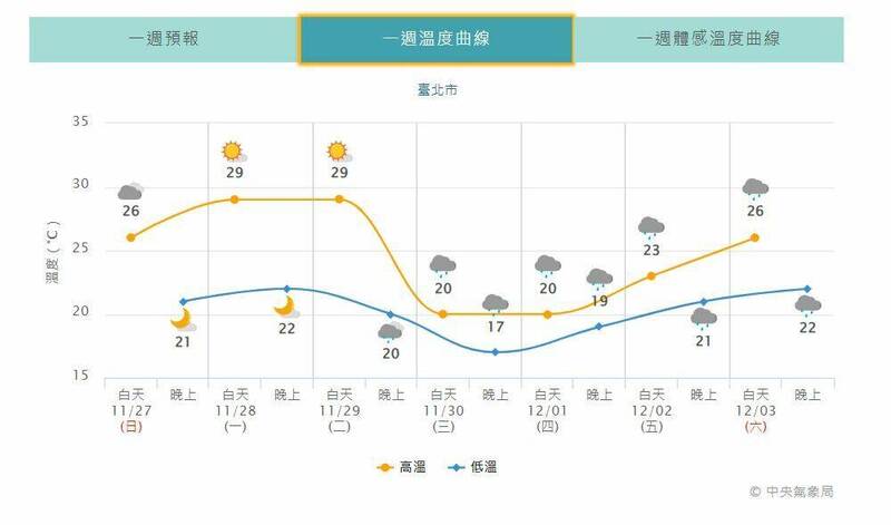
The temperature in the north, east, and northeast of central China will drop significantly, and other areas will also be cooler in the morning and evening; this is the temperature curve of Taipei City for the coming week.
(taken from Central Weather Bureau)
[Reporter Chen Xinyu/Taipei Report] Today (27th) the northeast monsoon has weakened. The whole of Taiwan feels warmer and less rainy than yesterday.
On Tuesday night, there will be a stronger northeast monsoon, the front will pass through the influence, and the temperature in the north will drop to 16 or 17 degrees.
The coldest time occurs in the early morning of Thursday, and the temperature gradually rises after daytime on Thursday, and the low temperature will return to 19 or 20 degrees from Friday.
As for whether it is the strongest wave of cold air in winter this year?
Zeng Zhaocheng, a forecaster of the Central Meteorological Bureau, said that on November 6, there was cooler air moving southward. Whether this wave of low temperature will be colder than that at that time requires continuous observation and evaluation. Currently, it is estimated that it has not yet reached the intensity of the continental cold air mass.
Please read on...
The Central Meteorological Administration stated that today (27th) the northeast monsoon has weakened, and the environment is easterly. The weather is fine and fine. The low temperature in various places is about 21 or 22 degrees. The daytime is a little warmer than yesterday. The high temperature in the northern and eastern half is 26 to 28 degrees, and the high temperature in the central and southern parts is 29 or 30 degrees.
Zeng Zhaocheng said that from today to Tuesday, the weather will continue to warm up and gradually turn dry during the day. The average temperature in the north is 21 to 29 degrees, and the whole Taiwan is mostly cloudy to sunny, but a strong northeast monsoon will strengthen its impact on Tuesday night. , Starting on Wednesday, the northern and central parts became colder and colder later, the northern part dropped to 16 or 17 degrees, and the high temperature was only 22 degrees; the central part had a low temperature of 18 to 20 degrees, and a high temperature of about 28 degrees; There are 29 to 32 degrees.
It will also start to rain from Tuesday to Friday. The temperature in the north, central, Yilan, and Hualien will drop significantly. There will be some short-term rain in the northern and eastern half. The central and southern regions will still be cloudy to sunny.
Starting on Friday and Saturday, the northeast monsoon began to weaken, and the temperature in the north of the central part, Hualien and Yilan rose slightly; there were still some short-term rains in the north and east of Yihua, and the central and southern regions were still cloudy to sunny.
In addition, from this evening to the evening until tomorrow, the western half of the area and Penghu, Kinmen, and Matsu are likely to have low clouds or partial fog that will affect visibility, so please pay attention to traffic going back and forth.